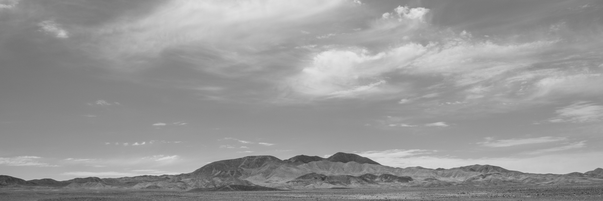
Journeying north from the Chilean capital of Santiago, there is a point, perhaps passing the town of Copiapó, around 27° S, when the vegetation stops and the desert begins in earnest; arid, parched, the land strewn with rocks and rubble. It is an unworldly landscape, one that at first sight would appear to deny the very possibility of human life, but that nonetheless has been inhabited by humans for many thousands of years. Passing the Tropic of Cancer, now around 22° S, as the plane begins its descent into the oasis of Calama, the mining capital of Chile’s Norte Grande, I have a bird’s-eye view of the land, of its terracottas and arenaceous yellows, of the whites of the salt flats, the die-straight roads that cut across the land, the tops of distant volcanoes shimmering in the heat; a mirage, a landscape suspended in time. Touching down on the tarmac, the contrast between the solid black and the buff land from which the runway is carved sticks in my mind.
Later that night, leaving the city of Calama behind us and heading into the unknown, the contrast returns to haunt me, the beam of the headlights illuminating snatches of the empty space around us; vast, menacing, uncertain. The nightlights dance demonically in the distance behind us, flickering orange and red: Calama and the neighbouring town of Chuquicamata, home to the world’s largest open-pit copper mine, its voracious appetite fed by multiple rows of pylons running in parallel to the road. Something about the landscape overwhelms me, a disturbing, almost hallucinatory quality. Already I feel the colossal energy that lies dormant beneath the surface of the land.
—
‘The story of the earth,’ writes Robin Wall Kimmerer in Braiding Sweetgrass (2013), ‘is written more truthfully on the land than on the page; the land remembers what we said and what we did.’ If this is true, Chile’s northern desert is blessed with a near-perfect memory, among the finest in the world. With some of the lowest rates of erosion, its landscapes are among the oldest on the planet, littered with artefacts and markings that record millennia of history, testament to the lives –and occasionally deaths– of those who have gone before us. It is among this flotsam and jetsam that the geoglyphs of Chug Chug—from geo, meaning earth and glyph, a sign or symbol—are found, a series of distinctive markings made from the contrast between the light sandy earth and its covering of dark brown stones. Spread across an area covering some 190 square kilometres, Chug Chug is one of the largest collections of geoglyphs in the world, representing a cultural tradition spanning the last 2,500 years of the pre-Hispanic period (1,000 BCE to 1,500 CE) and forming part of a complex network of routes linking the oases of Pica, Quillagua and Calama along a north–south axis, and the coastal settlements of the Pacific and the Andean highlands from east to west. Over the next few days, I have the privilege of shadowing an interdisciplinary team of anthropologists, archaeologists, geographers and conservation experts from the Atacama Desert Foundation on a field trip to survey the geoglyphs. For now though, it’s late, I’ve been on the road all day, I decide to turn in for an early night.
—
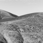
The first light of dawn reveals the desert in all its splendour, unchanged, unchanging, the land waiting expectantly for the sun to rise over the distant hills. From our camp, it is a twenty-minute walk to the main sierra, which has the largest collection of geoglyphs (around four hundred and counting, one of 18 separate sites discovered at Chug Chug). I follow the path to a rudimentary viewpoint installed by the Atacama Desert Foundation last year at a safe distance to protect the geoglyphs from further human damage. Clustered on the east-facing slopes of the sierra’s five hills –a detail, it strikes me that may not be wholly accidental– I watch the geoglyphs and wait patiently for the sun to rise. When it finally does appear from behind the distant mountains, the hills are struck by its horizontal rays, a rich, luxuriant light that works its way gradually down the slopes, illuminating the contours of these curious shapes that have marked the desert for millennia: crude representations of human figures, lizards, felines, llamas, fish, circles and the stepped rhombus, or chakana>, commonly referred to as the Andean cross.
Researchers who have worked extensively on cataloguing the geoglyphs have identified three groups of symbols: anthropomorphic, the hypothetical representation of an important figure in the religious, political or ideological realm; zoomorphic, of species such as camelids, used for transport in the desert, and deep-sea fish, which attest to the presence of coastal fishing communities; and finally, geometric figures, which may have served as markers for different ethnic groups. Yet while researchers may have been able to shed some light on the meanings of the geoglyphs, their full significance remains largely shrouded in mystery. Theories range from simply functioning as landmarks to being bound up with the cult of the mountains and Andean myths and divinities. However, some of the most recent and comprehensive work on cataloguing and systematizing them has focused on a more prosaic explanation, centred around their importance as part of pre-Hispanic caravan traffic and trade between the indigenous peoples of the region. For Gonzalo Pimentel, Director of the Atacama Desert Foundation, their size –some measure up to 15 metres– and high visibility suggest they were ‘strategically placed to reach a wide audience as an active mechanism to distinguish and denote belonging to specific social groups.’ Moreover, imprinting these signs on this apparently ‘empty’ landscape, a place of transit, or ‘non-place’ in anthropological terms, creates a sense of continuity or permanence, which, he explains, manifests ‘the power to objectify the presence of other places and people.’ On the hills, in the markings carefully arranged on their slopes, is written a history, ultimately unknowable perhaps, of peoples and cultures all but lost to the sands of time. It is, as Pierre Minvielle reminds us in his essay on schematic rock art, a form of proto-writing, once described by Abbé Breuil as ‘the page before this one.’
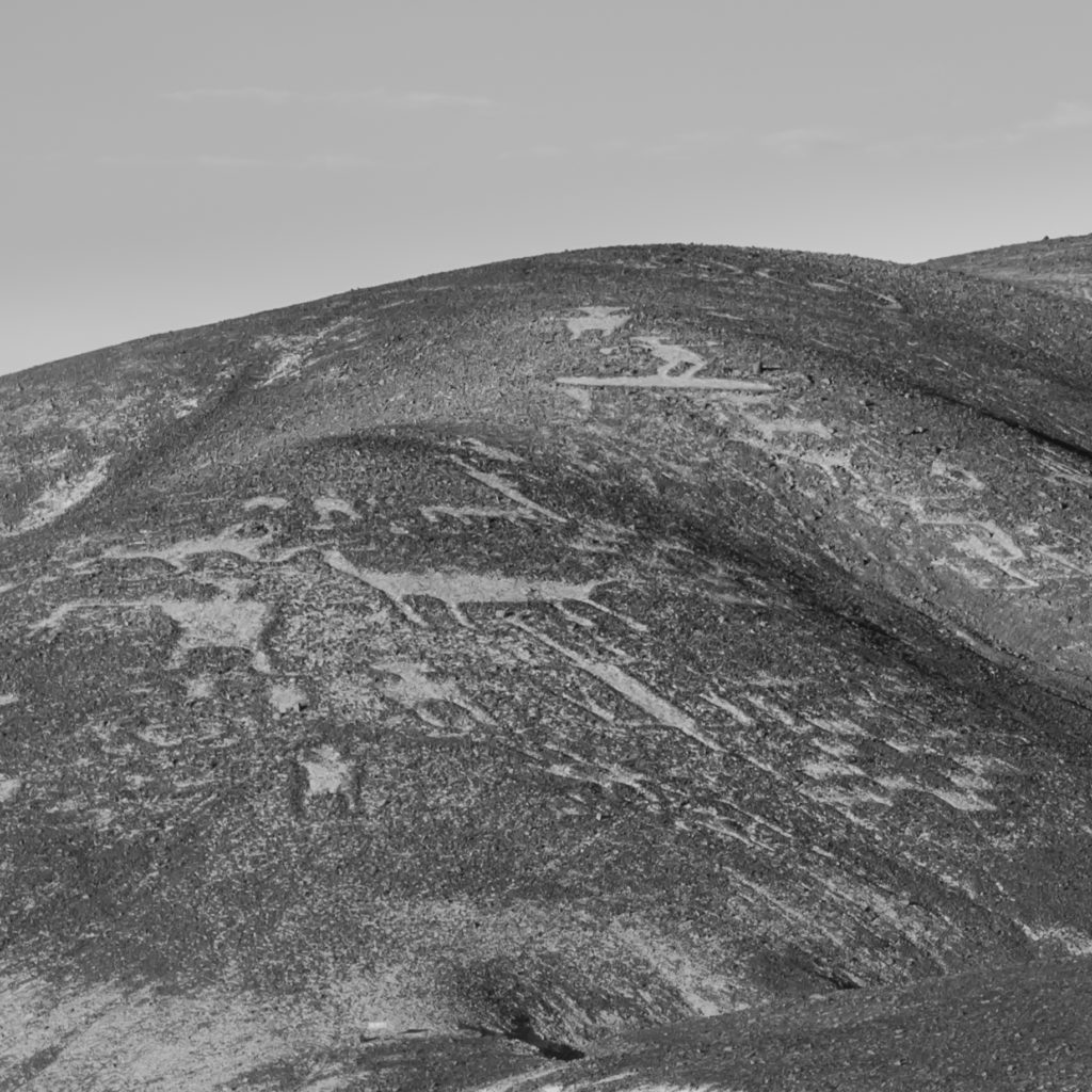
Like all histories, the geoglyphs have evolved over time: looking back to the earliest designs, we find the use of an ‘additive’ technique, which works by arranging the earth and stones to create a light border around a dark shape; however, some three and a half millennia later, by the time of the Spanish invasion, the designs were almost exclusively executed using a ‘subtractive’ technique, removing the darker top layer of stones to leave visible the lighter earth underneath. Yet as Pimentel is keen to point out, it was not only technique that evolved, but also the designs themselves. While the earliest specimens are characterized by crude, unadorned human forms and more detailed animal figures, later images see this trend reversed: humans are adorned with tunics and headdresses, equipped with implements such as shields and axes; instead, it is the animals that are simplified, reduced to abstract representations in what perhaps serves as a curious commentary on how humans came to see themselves in relation to the animal kingdom.
Yet if the geoglyphs are important to researchers and experts, offering a puzzle to be solved, they are equally important, if not more so, to the local indigenous communities that still live in the area. While the thriving cultures of their forbearers, and with them the knowledge of the language and traditions associated with these signs, may have all but vanished, Chug Chug’s importance as a sacred site lives on.
For Esteban Araya Toroco, Chug Chug is a magical place pervaded by a powerful energy. A young 47, he remembers hearing about the site as he was growing up, although it was not until around the age of 30 that he made his first visit: ‘I’d heard about the geoglyphs but the first time I went there, it was incredible,’ he explains, before going on to describe the site’s significance as a point of confluence for the ancient caravan routes that criss-cross the region. Esteban represents the Autonomous Council of Ayllus Without Borders. <em>Ayllu,</em> a word for community or people in the indigenous Kunza language, traces of which still survive among the inhabitants of the village of San Pedro de Atacama, and ‘Without Borders,’ a reminder that the communities he represents predate the drawing and redrawing of borders across their ancestral lands, most notably Chile’s annexation of the mineral-rich northern desert from Peru and Bolivia during the War of the Pacific in the nineteenth century.
Esteban is convinced that somewhere in the area lies a settlement or campsite waiting to be discovered: ‘there has to be a place where people lived, where they would have spent various months at a time; this wasn’t just somewhere people passed through.’ For Esteban, this gap in the community’s collective memory is a powerful reminder of the loss of the knowledge of his ancestors, which might offer clues to help discover the location of the site, while for Pimentel and his team, it acts as a reminder of just how little we know, of the mysteries contained in this immense open space.
—
We spend the days moving across the surface of the desert, aided by the foundation’s four-wheel-drive, approximately following the course of the ancient caravan routes and stopping from time to time to catalogue some of the lesser-known geoglyphs. As we walk together under the sun, I am acutely aware of its intense luminosity, of the aridity of the desert, of the absence of any moisture whatsoever. Yet despite the pervading sense of inhospitableness, the tracks serve as a reminder that these distances were once covered without the luxury of motorized transport. Still visible to the trained eye, having perdured the passing of millennia, they snake across the desert in shallow parallel furrows. Pimentel shows us how to distinguish between the lines made by different animals: those of horses, narrow and straight, and the broader, more erratic marks left by caravans of llamas. These were, he reminds us, long and arduous journeys, with no sources of water for days on end and nowhere to shelter from the incessant glare of the ever-present sun.
With the keen eye of an anthropologist, Pimentel reveals how this apparently empty space is bristling with clues to multiple pasts. The climate is such that the only element acting on the objects we encounter is the sun. When, from time to time, we come across the bones of some unfortunate animal, they are brittle and calcareous, baked and bleached white by its rays. Who can say how many years –or decades– they have been lying there? From the nitrate boom of the late nineteenth and early twentieth centuries, we find green glass bottles and iron cattle shoes scattered across the pampa, the latter fitted by drovers to protect the hoofs of their livestock from the scorch of the earth. Reaching further back in time, we find rocks arranged in shelters that once protected people from the winds that whip across the desert at sundown, signs of fires lit beneath the earth and covered over to create the warmth of a makeshift bed, piles of stones arranged in ceremonial cairns and tombs, telling of the lives –and, for those less fortunate, deaths– of the people that once transited these lands. This debris of the past is a treasure trove for experts. An article by Luis Briones describes how the remains of a young girl found to the north, wrapped in the skin of a seabird and wearing leather sandals made from sea lion, indicate the presence of coastal groups and suggest the seasonality of their journeys, which were most probably made during the summer to coincide with the greatest availability of resources. The dating of the tomb to approximately 1400 BCE tells us that the caravans predate the geoglyphs by a considerable period of time.
Approaching a cairn, Pimentel directs our attention to small pieces of copper mineral lying on the ground, once thrown into the air as an offering, or payment, for safe passage across the desert, now scattered at our feet. Almost imperceptible at first, as we draw closer, their density increases until a sea of turquoise spreads out around us. I think of Chuquicamata, of that gaping copper mine ripped piecemeal from the flesh of the earth. These peoples, it appears, also mined for copper, albeit on a smaller, more human scale. It is the same activity, yet separated by millennia and two cultural contexts that could not be further apart. Somewhere along the line, a profound loss has occurred, the loss of our respect for the land, of an awareness of the limits of human activity, of a sense, when all is said and done, of balance. Yet this is not equally true for all: for the survivors of those pre-Hispanic cultures, that sense of respect, as Esteban explains to me when we talk later that week, the tradition of making offerings and payments to give something back to the land, lives on. ‘When we go,’ he tells me, ‘we take coca leaves, alcohol and drinks and give thanks looking across toward the volcanoes, the ceremonial hills of the cordillera, invoking them, asking their permission, giving a payment to mother earth and to our ancestors, offerings made when setting out on a journey or arriving safe at a destination.’
—
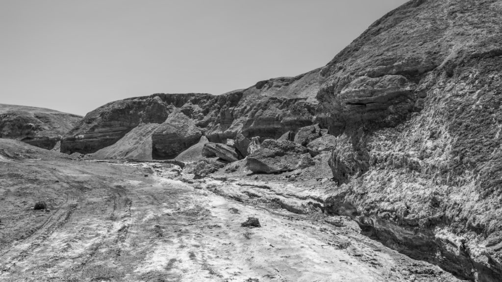
The following morning, we rise early and prepare the four-wheel-drive for a long day: lunch, sun protection and, of course, water. Setting off due north, our first destination is the Aguada de Chug Chug –literally a waterhole– after which we will continue along the bed of the Quebrada de Chug Chug, or gully. As the only source of water between the oasis of Quillagua, some 70 kilometers to the north-west, and the point where the route rejoins the River Loa, some 40 kilometers to the south, the importance of the <em>aguada</em> cannot be underestimated. Our vehicle jolts as we cross the pampa in the morning sun. It is not long before we leave its flat space behind us, dwarfed by the mountains rising up to our north, their rounded contours defined by the rills and channels that run down them. Thus do we enter the gully, following its course, stopping occasionally to negotiate points where the route has been eroded or washed away by last year’s rain, until at last we emerge into a sort of basin. In front of me rises up a sierra of mountains whose rock contains an implausible spectrum of colours: ferrous oranges, purples, browns and cupriferous greens; a mineralogist’s paradise. Behind me, dry scrub spreads out across the basin, the first vegetation I have seen in days, telling of moisture below the surface of the ground. We follow its trail, noting the presence of grass as we draw closer, leading us to a small cave that extends down into the rock. There before us is the Aguada de Chug Chug. With our abundance of drinking water in the car, it seems little more than a dark, murky pool. However, to those who once made the gruelling journey from Quillagua to Calama, travelling for days under the sun with no escape from its heat, this was a lifeline, a chance to quench their thirst, to recover from the hardships of the desert and allow their weary herd to drink its fill. If they were travelling due south, they would drink safe in the knowledge that the most dangerous stretch of their journey was behind them, that it was only another day or so to Calama and the abundance of the River Loa; if they were travelling due north, on return to Quillagua, they would know to stock up well, for it would be many days before they would see water again.
We survey the geoglyphs in the surrounding area and stop for lunch, letting the landscape work on our minds. I can feel the vulnerability of being in the desert: no food, no shelter and, save for the <em>aguada</em> beside us, no source of water for miles around. I think again of the bones from the previous day, brittle, calcareous, bleached by the sun, of the tombs and the cairns. I feel fragile, perishable.
We set off again, following the gully bed as it widens and grows deeper, the route increasingly difficult to navigate, the jolts of our vehicle more severe. When at last we come to a stop, it is not because we have reached our destination but because the land will allow us to go no further. We get out to inspect the obstacles in front of the wheels and take in the lie of the land. In some parts, the watermarks on the sides of the gully are over a metre high and it is tens of metres wide. I try to imagine the fast-flowing waters rushing down from the mountains, tearing through this channel and on out to sea. Yet the land is so dry and the climate so arid it seems impossible that the gully could ever be filled with running water. I wonder if some of the erosion comes from an earlier age, from glaciation perhaps. Yet it is equally true, as recent flooding in the north of Chile showed, that land this dry does not absorb the rain, instead sending it cascading down the sides of the hills, down into the gullies and ravines, where it collects in gushing torrents; whence the rivers’ deadly power. For now though, there is nothing, the riverbed is parched and cracked, streaked with white salt marks, baking under the afternoon sun.
There are more geoglyphs further along the course of the gully, but the distance is too far to cover without the help of motorized transport. For now, at least, they remain inaccessible, a reminder of our impotence against the might of the land. As we make our way back along the gully, the walls and hills close in around us and in the shadows cast by the afternoon sun I reflect on the still and silent power of that mortal landscape, on its capacity to evoke awe and reverence among its pilgrims, of which I am one.
—
The landscape and its geoglyphs are not respected equally by all. According to recent estimates by the Atacama Desert Foundation, over a fifth of the markings have now suffered irreparable damage as a result of various human activities. On a small scale, there is the underlying threat of informal tourism and the series of gradual modifications made to the sierra by visitors improvising paths in an attempt to see the geoglyphs up close, in some cases passing directly over them and even creating their own. It is a problem that has been largely addressed since the foundation established a permanent presence at the site in 2015. On a slightly larger scale is the damage caused by vehicles passing through the area, most notably when the Dakar Rally tore across the site in 2015, leaving a trail of destruction in its wake. The tyre tracks left behind by the vehicles are all too visible across the desert, scarring the memory of a land that does not readily forget. Despite attempts to hold the organizers of the event to account and the hope that tighter regulations can be put in place to prevent the re-occurrence of similar damage in the future, the simple fact is that once done, the destruction of this archaeological heritage cannot be undone.
Finally, on the largest scale, there is the ever-present threat posed by mining activity in the region. Copper remains the driving force of Chile’s extractivist economy, a fact to which the sprawl of transient cities such as Calama readily testifies. Once an oasis in the desert and a point of confluence for the pre-Hispanic caravans, the city has grown rapidly in recent decades, fuelled by the easy money to be made exploiting the region’s vast deposits of the red metal. In the 2000s, Calama swallowed the population of the neighbouring town of Chuquicamata whole as the operations of the mine rendered the area unfit for human habitation. Yet if copper has been mined in these lands for centuries, the scale of recent operations is unprecedented. From its origins at the end of the nineteenth century, the Chuquicamata mine has grown to a gaping chasm over four kilometers long, two kilometers wide and 800 metres deep, with the pit reflected above the surface in the massive human-made mountain of sterile rubble that towers over the complex. By volume, it is the largest open-pit mine in the world, with round-the-clock operations that feed the global manufacturing supply chain. With industry on this scale comes money, and with it power, a dynamic in which environmental and conservation concerns are often relegated to second place.
Sites such as Chug Chug live in the shadow of this power and have limited means to resist it: a recent power line project put the geoglyphs directly in its line of sight, and there is an almost daily battle to control prospectors and prevent their pick-up trucks further scarring the land. It is a David and Goliath struggle that pits grass-roots conservation against the economic interests of big business. Yet for groups such as Ayllus Without Borders, the Atacama Desert Foundation offers a glimmer of hope, a means to defend, as Esteban explains, ‘that which cannot defend itself, namely mother nature, the hills, the volcanoes, the cemeteries, our ancestors.’ A means to defend, when all is said and done, the desert and its sense of wilderness.
—
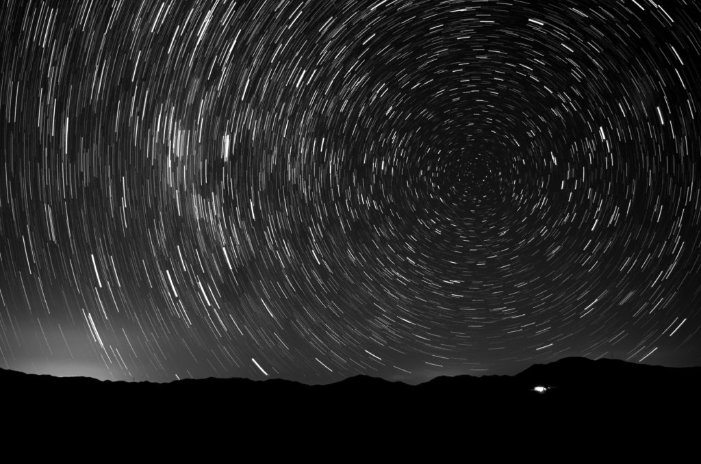
The darkness envelopes us as we emerge into the cold, dark night, leaving behind the snug of the campsite. As we walk, a crescent moon sets over the sierra, leaving only the stars in the sky. Returning to the viewpoint I visited on my first day, the Milky Way arches over our heads, a shower of speckled silver, leading our gaze from horizon to horizon. The desert, its vast open space, spreads out around us. As I set up my camera, I think of the caravans crossing this space, alone in the night, guided by these very same stars. I think of the strange symbols they left behind, markers in space and time, a history of human resilience and survival in a hostile and seemingly uninhabitable environment. I recall and understand Wallace Stegner’s words in his ‘Wilderness Letter’: ‘we need wilderness,’ he wrote, ‘because it is the challenge against which our character as a people was formed.’ Over the last few days, contemplating the enigma of these markings, the mystery that surrounds the people who left them behind, has reminded me of the fragility of our own existence, of our overdependence on technology and the manufactured environment, of the delicate complexity and imbalance of our way of life, all-too vulnerable—as we realize when we step outside—to collapse, of the rapacious rate at which we are depleting the resources of a planet with a finite carrying capacity. Standing here under the stars, I am struck by something primordial, a sense of wonder, the power of the land.
There on the horizon, to the east, is our camp, the warm yellow glow of the dome visible in the blackness of the landscape. To the west, a chemical miasma, the grimy pall of Chuquicamata, of Calama, the city that serves it. Yet its power, the electricity of human life, is dwarfed by the latent energy of the surrounding landscape, of the firmament above, a deeper and slower energy, one that will outlive our civilizations and their vanity, an energy that will one day reclaim these spaces for its own when we who inhabit them are gone, leaving behind nothing more than the markings we make on the land.
This article was first published in issue XIX of you are here: the journal of creative geography (2017).
Comments are closed.